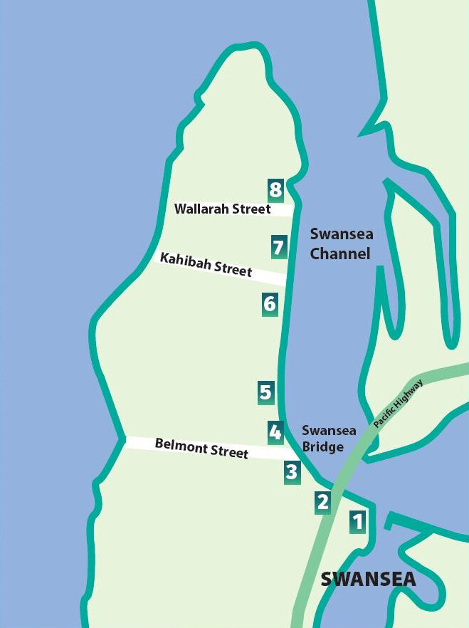
Map of Locations

1. RSL / Stockyard Point
Stockyard Point was used for holding stock by John Boughton, who owned 599 acres from the Pacific Highway to Swansea Heads. It was then used by Henry Denny who was arrested in 1841 for cattle stealing. In the 1850s, when settlers began arriving, it was again used for stock.
The RSL Club began in an army hut here c.1936.
On the Blacksmiths side was a timber gantry used for loading coal from North Wallarah Mine.

Stockyard Point c1920 (site of the present-day RSL) with Black Ned’s Bay in the background. Image: Kevin Lunn
2. Bridges
Prior to the bridge, most channel crossings were made in William Boyd’s flat-bottomed punt.
In 1881 a bridge was built, originally for a railway carrying stone for the channel’s northern retaining wall. It was replaced by a single lane, timber decked bridge in 1909.
The present northbound bridge opened in 1955 with the fourth bridge providing the additional two southbound lanes in 1989.

First bridge was a swing railway bridge built to carry stone from The Plains (Caves Beach) Quarry to build the retaining walls. Image: Cultural Collections, Lake Macquarie
3. Wharf
The original Town Wharf (1886) was once a bustling hub from where boats and ferries transported cargoes and people across the lake and further afield. There was a storehouse, waiting room, a horse trough, along with windmill and water tanks.
In 1920 a new wharf, mainly for the use of ferries, was built opposite where the Swansea Pool is now. It was used into the 1940s and demolished c.1960.

Passengers on the ‘New Wharf’ waiting the arrival of the ferry. The original Town Wharf is clearly visible in the background Image: Cultural Collections, Lake Macquarie
4. Swimming Pool / Previously Police Station
The site of the 1887 police station, lock-up, residence and courthouse were on five acres to cater for the constable’s horses and milk cows.
After the police command was moved to Belmont, the courthouse was moved to Catherine Hill Bay and the residence to Bowman Street, Swansea.
During the 1920s to 1940s the five acres and adjoining recreation area was popular with mineworkers from Cessnock and West Wallsend for picnics and camping.

c.1930s Campers start to arrive at the Swansea campground, now Bill Quinn Memorial Park. Swansea School can be seen in the background. Image: George Boyd
5. Swansea School
Swansea’s very first school was at Galgabba Point before being moved to The Plains (Caves Beach) for the children of those working on the Swansea Channel retaining wall works.
A school and teacher’s residence were built on the present site in 1887.
The original building was demolished in 1980 following an arson attack. In 1983 the residence was moved to Minmi to make way for an administration block, opened 1996.

c.1917 Teachers are Mr. Byrne standing in front of the 1910 building and his daughter Mrs Turner standing near the 1887 building. Image: George Boyd
6. Fishing Industry
During the 19th century, a Chinese settlement was located along the Channel in the vicinity of Kahibah Street and surrounds.
Residents at the settlement participated in fishing, farming and cabbage tree hat making industries.
Fishing was an important industry for the area, and Lake Macquarie. In the 1860s, up to 70 tonnes of cured fish was shipped to the Sydney markets.

Remains of jetties at the site near Kahibah St. Image: Cultural Collections, Lake Macquarie
7. Tom Humphreys Reserve
Boat builder Tom Humphreys lived and worked at 3 and 5 Channel Street, where he established his boat-building yard in 1917.
He designed and built many hundreds of pleasure and racing boats, including the revolutionary tuck stern surfboat in 1945. This design gave locals an edge over competitors and was soon adopted by all surf clubs. It remains the standard design specification for all surf boats in Australia and the rest of the world.

c.1937 in front of Tom Humphrey’s boatyard, for the launching of an unknown vessel. The bow of which is visible at bottom right of picture. Image: Gordon Humphries
8. Caravan Park / Liberty Green
The area now occupied by Swansea Lakeside Caravan Park, previously known as Swansea Gardens due to the well-maintained setting, was named Liberty by the early owners of the land, Samuel and Albert McDonald – to commemorate their American heritage.
In the early 1920s, a time of great economic hardship, the land along the lake’s shores was occupied by squatters in small dwellings made from bush poles, second-hand timber, often clad with lime and cement coated hessian or galvanised iron.

Aerial view of Liberty Green 1970’s. Housing on the point and island was removed by 1996; replaced with nature reserves. Image: Gordon Humphries


